Will We Experience a Warmer-than-Normal Summer? Active Hurricane Season?
3 min readSo far, we’ve spent much of 2020 under neutral or weak El Niño conditions in the Pacific Ocean. This had led to a highly variable weather pattern. In recent weeks, water temperatures throughout much of the equatorial Pacific have been gradually cooling but still within the parameters of a neutral phase of ENSO (El Niño – Southern Oscillation), leading to storms and a lot of severe weather.
When the average water temperatures over the central equatorial Pacific fall to more than a half of a degree Centigrade below normal for a period of 90 days, it becomes classified as a La Niña event.
Recent Water Temperature Anomalies
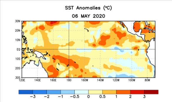
Source: NCEP/NOAA
The picture above is a compilation of water temperatures from February to May, looking across the Pacific and below the surface to 400 meters. An expansion and intensification of below-normal water temperatures is evident just below the surface over the past several months. We expect this trend to continue with more below-normal anomalies reaching the surface during the summer. Given the recent cooling and so much cool water below the surface, the process may be leaning stronger and faster than expected.
A Look at Below the Surface
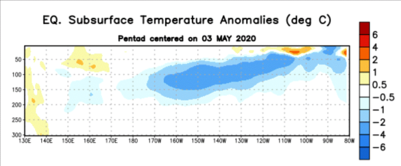
Source: NCEP/NOAA
Although the International Research Institute (IRI) probability of a La Niña event late in the summer and fall stands around 30%, we believe there is a higher chance of La Niña given the parameters described above.
What Does this Mean for Weather Expected this Summer?
The correlation of a transition from El Niño or neutral conditions in the summer is warmer to hotter than normal for much of the nation. Many of the public forecasts and models are showing a top 10 warm June nationwide. One of the years that we are tracking right now with a similar profile (known as an analog year) in Pacific water temperature anomalies is the summer of 2016, the hottest on record. While we may not have the hottest summer, odds favor hotter than normal, perhaps like the recent hot summers we have seen in the past 10 years.
A La Niña event is also favorable for storms in the Atlantic Ocean and Gulf of Mexico. We have already had 3 named storms just as the hurricane season gets underway. La Niña increases the odds of a higher number of storms and landfalls along both the East and Gulf Coasts. We are expecting a very active season as wind shear decreases and oceanic water temperatures warm during the summer.
For more regular weather updates, register for our monthly Energy Market Intel Webinars by visiting www.constellation.com/marketintelwebinar.